


Pajaro Valley Health Care District History
To form a healthcare district that could acquire Watsonville Community Hospital, Senate Bill 418 was introduced by State Senator John Laird and coauthored by Assembly members Robert Rivas, Mark Stone, and Senator Anna Caballero. The bill passed unanimously and was signed into law by Governor Gavin Newsom on February 4, 2022. The District was created by the Pajaro Valley Healthcare District Project, a partnership between Santa Cruz County, the City of Watsonville, Salud Para La Gente, and the Community Health Trust of Pajaro Valley. This collaboration saved the hospital from bankruptcy and established public oversight. The District extends from Aptos to Pajaro, spanning two counties. While the Santa Cruz County Board of Supervisors made initial appointments to the District board, since then board members have been elected by the public. The board recognizes that social determinants of health such as race and ethnicity, living conditions, occupation, documentation status, zip code and income affect health outcomes. A balanced healthcare system, including the sustainability of Watsonville Community Hospital, is crucial to addressing these disparities.
District Mission, Vision, Values
Our Mission:
We are the trusted, equitable healthcare partner and provider our diverse families, friends, and neighbors deserve.
Our Vision:
To be our community's champion and advocate for health and wellness to improve the lives of our community for generations to come.
Our Values:
We put people first. We put the health and wellbeing of people first in every decision and every experience.
We strive for excellence. As stewards of our community's health, we commit to providing the highest quality of care and exceeding expectations.
We earn trust. We work as a team to earn the trust of everyone we interact with.
We are family. We embrace the family traditions, cultures, and diversity of our community every day.
The Pajaro Valley Health Care District was named the Santa Cruz County Chamber of Commerce 2022 Organization of the Year.
This video showcases our history from the creation of the Pajaro Valley Health Care District Project to becoming a new Health Care District within the state of California, and the effort to help us return to our roots as a non-profit hospital, owned by our community.
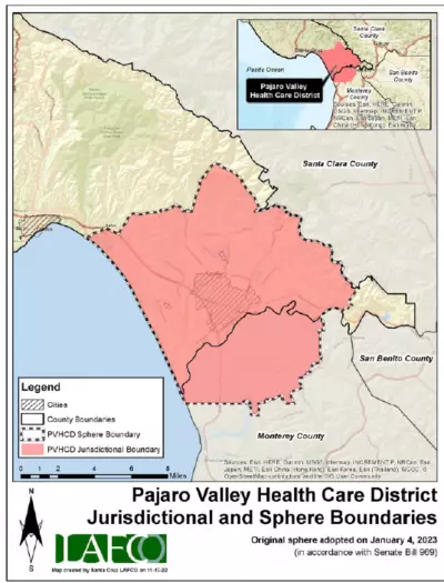
District Map
The boundaries of the Pajaro Valley Health Care District, which cover 108 square miles from Aptos to Pajaro, can be explored using Santa Cruz County's GISWeb. When you click the link, accept the disclaimer and then open the Legend in the upper left. Go down to the Special Districts and expand the option by clicking on the arrow/triangle. Select Pajaro Valley Health Care District which is the first option by clicking the box.
If you live in Santa Cruz County and would like to find your home and specific property parcel, you can select Parcels On/Off on the left side of the map. If you live in Monterey County, your county does not have a gis map with a Pajaro Valley Health Care District overlay, but as a general reference, the Health Care District boundaries are almost the same the Pajaro Valley Unified School District.
District Population & Elections
The 2023 estimated population of the District is 94,349. As of Feb. 27, 2024, there were 43,229 registered voters in Santa Cruz County and 4,497 registered voters in Monterey County that live within the District boundaries.
Voters who live in the District will receive information from their county election department whenever there is an item on the ballot relating to the Pajaro Valley Health Care District. Following are links to those election departments: Santa Cruz County and Monterey County.